
United States Earthquakes
M3.62 0 km W of Angwin, CA
21 hours ago · Depth 8.7 km
Recent United States Earthquakes (Past 24 Hours)
- M2.1044 km NW of Toyah, Texas
- M1.9041 km E of Pedro Bay, Alaska
- M1.7053 km SE of Cordova, Alaska
- M2.0320 km SE of Pāhala, Hawaii
- M1.716 km ENE of Pāhala, Hawaii
- M1.6619 km NNE of Indio, CA
- M2.1512 km SE of Sunol, CA
- M2.7516 km NNE of Pāhala, Hawaii
- M1.909 km NNW of Susitna North, Alaska
- M1.7016 km SSE of Pāhala, Hawaii
- M2.40132 km SE of Chignik, Alaska
- M2.0516 km SE of Pāhala, Hawaii
- M2.1219 km ESE of Naalehu, Hawaii
- M1.8111 km SE of Pāhala, Hawaii
- M2.1115 km E of Naalehu, Hawaii
Source: USGS
This page tracks the latest available U.S. earthquakes using USGS data and explains the major fault zones, tectonic plate boundaries, early-warning systems, and high-risk regions such as California, Alaska, and the Pacific Northwest. It also highlights key monitoring networks and notable historical earthquakes.
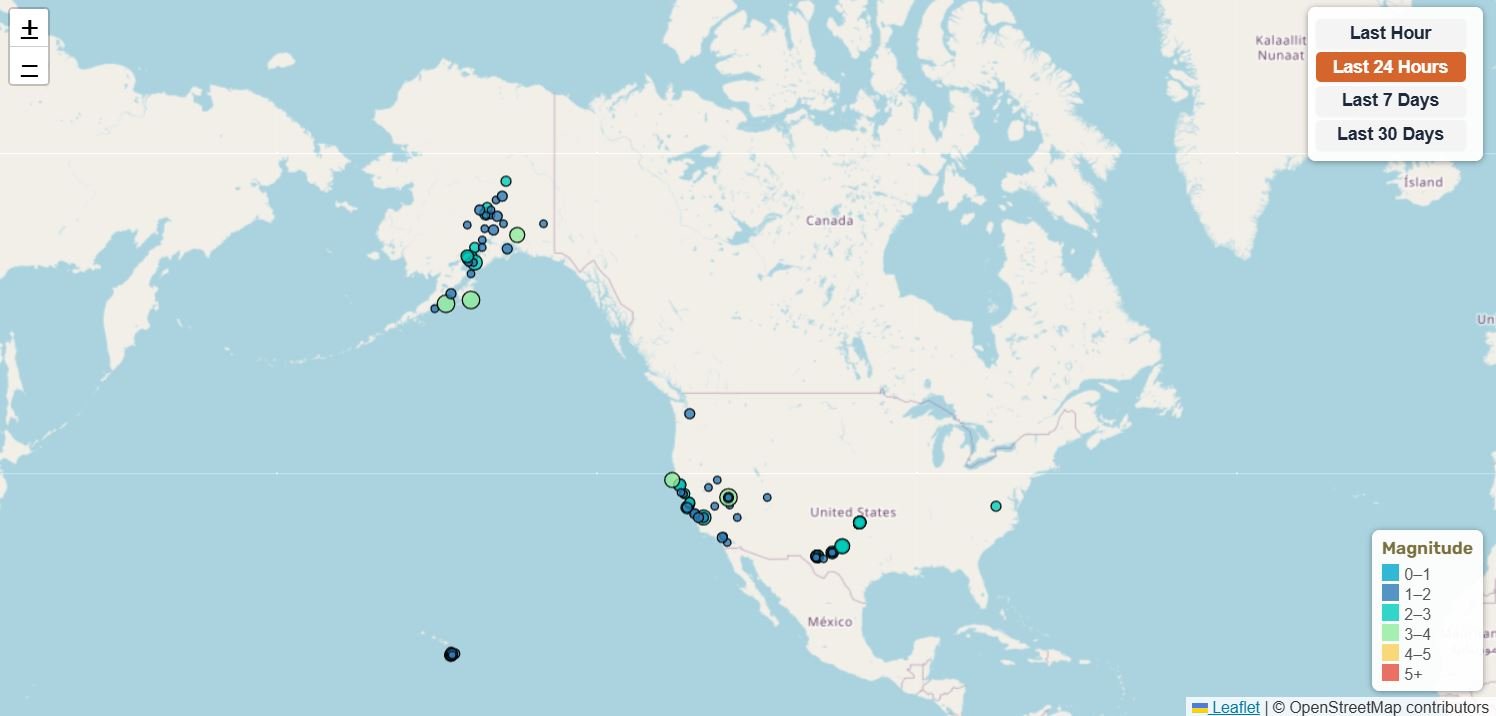
Coverage Notice: This map provides full U.S. seismic coverage. Border areas may appear on multiple regional maps to ensure no earthquake activity is missed. This overlap follows best practices in professional seismic monitoring. Note: This page updates on refresh. For the latest earthquake counts and statistics, please refresh the page.
📊 United States Earthquake Statistics
0 km W of Angwin, CA
44 km W of Happy Valley, Alaska
11 km N of Redwood Valley, CA
2025 Sand Point, Alaska Earthquake
Magnitude 1.5+ • Data from USGS
🔔 Latest United States Earthquakes (M4.0+)
| Mag | Location | Date & Time | Depth |
|---|---|---|---|
| M4.50 | 81 km NNE of Adak, Alaska | Jul 7, 2026, 6:07 PM UTC | 172.4 km |
| M4.00 | 44 km W of Happy Valley, Alaska | Jul 6, 2026, 5:36 AM UTC | 108.0 km |
| M4.10 | 231 km ESE of Attu Station, Alaska | Jul 3, 2026, 11:03 PM UTC | 16.7 km |
| M4.00 | 231 km ESE of Attu Station, Alaska | Jul 1, 2026, 10:50 AM UTC | 63.3 km |
| M4.10 | 229 km ESE of Attu Station, Alaska | Jul 1, 2026, 9:01 AM UTC | 10.0 km |
| M5.50 | 218 km W of Bandon, Oregon | Jun 29, 2026, 11:35 AM UTC | 10.0 km |
| M5.30 | 35 km SSW of Cordova, Alaska | Jun 29, 2026, 3:32 AM UTC | 13.3 km |
| M4.30 | 247 km ESE of Attu Station, Alaska | Jun 28, 2026, 3:18 AM UTC | 54.9 km |
| M4.70 | 231 km ESE of Attu Station, Alaska | Jun 27, 2026, 4:35 PM UTC | 10.0 km |
| M4.20 | 27 km WNW of Hope, Alaska | Jun 27, 2026, 5:25 AM UTC | 47.9 km |
Updated: Jul 8, 2026, 7:18 PM UTC
United States Earthquake Hotspots – Last 24 Hours
Earthquake activity by region, updated automatically using USGS data.
- California experiences between 10,000 – 40,000 earthquakes per year, most too small to feel.
- Alaska produces more large earthquakes (M7+) than any other U.S. state, per decade.
- The Cascadia Subduction Zone is capable of generating megathrust earthquakes similar to Japan’s 2011 Tōhoku event.
About Earthquakes in the United States
The United States experiences more earthquakes than any other highly populated region, with thousands of events recorded annually. Most activity is concentrated along the Pacific Plate–North American Plate boundary, particularly in California, Alaska, and the Pacific Northwest. The U.S. Geological Survey (USGS) and regional seismic networks monitor nationwide earthquake activity 24/7.
Who Monitors Earthquakes in the U.S.?
The United States relies on several major scientific networks, including:
- USGS (U.S. Geological Survey) – National earthquake monitoring and hazard assessments.
- Caltech Seismological Laboratory – Research and seismic operations across Southern California.
- SCSN (Southern California Seismic Network) – High-resolution monitoring of California’s most active faults.
- CGS (California Geological Survey) – Fault mapping, hazard zones, and geologic analysis.
- ShakeAlert – Earthquake early warning system for the West Coast.
- MyShake App – Public early warning alerts and real-time reports.
Key U. S. Fault Zones
The most active and hazardous faults in the United States include:
- San Andreas Fault – Major strike-slip boundary between the Pacific and North American Plates.
- Hayward Fault and Calaveras Fault – Both faults connect so a rupture on one could easily trigger movement on the other.
- San Jacinto Fault – One of Southern California’s fastest-slipping faults.
- Garlock Fault – Important left-lateral fault across Southern California.
- Cascadia Subduction Zone – Capable of M8–M9 megathrust earthquakes.
- Mendocino Triple Junction – Intense seismic zone where three major plates meet.
Tectonic Setting
Earthquake activity in the United States is concentrated along the boundary between the Pacific Plate and North American Plate. The West Coast’s seismicity is mainly driven by California’s strike-slip faults, the subduction zone in Alaska, and the Cascadia megathrust in the Pacific Northwest (Washington and Oregon), resulting in one of the most active tectonic regions globally.
Notable United States Earthquakes
- 1906 San Francisco Earthquake – Devastating M7.9 rupture on the San Andreas Fault.
- 1989 Loma Prieta Earthquake – Major Bay Area shaking during the World Series.
- 1994 Northridge Earthquake – Destructive blind-thrust quake in Southern California.
- 2019 Ridgecrest Sequence – Large M6.4 and M7.1 ruptures in the Eastern California Shear Zone.
Earthquake Early Warning in the U.S.
The ShakeAlert system provides seconds of advance warning before shaking arrives, allowing people to quickly prepare. Alerts are delivered through mobile applications (the MyShake App) public systems, and institutional networks throughout California, Oregon, and Washington
🗺️ Related Maps
View broader region: Global Earthquakes | North America Earthquakes
View specific states: California | Alaska | Washington