
Alaska Earthquakes– Current Map & Updates
M3.80 49 km ESE of Halibut Cove, Alaska
2 hours ago · Depth 26.9 km
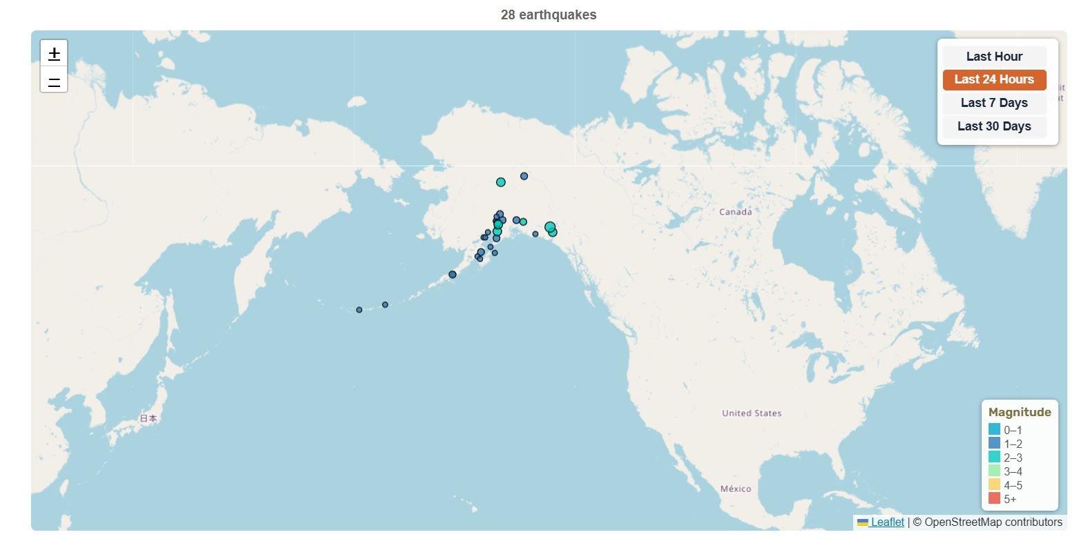
Recent Alaska Earthquakes (Past 24 Hours)
- M1.7060 km SSW of Central, Alaska
- M1.6018 km N of Skwentna, Alaska
- M1.5026 km ENE of Susitna North, Alaska
- M2.8058 km WNW of Happy Valley, Alaska
- M3.1048 km ESE of Halibut Cove, Alaska
- M3.8049 km ESE of Halibut Cove, Alaska
- M2.2044 km SE of Fox River, Alaska
- M2.5039 km SW of Karluk, Alaska
- M3.7035 km SW of False Pass, Alaska
- M1.703 km ENE of Big Lake, Alaska
- M2.1030 km SSW of Denali National Park, Alaska
- M1.7075 km W of Karluk, Alaska
- M2.1016 km E of Point Possession, Alaska
- M2.4026 km SSW of Petersville, Alaska
- M2.4026 km W of Ivanof Bay, Alaska
Source: USGS
Monitor the most recent earthquake activity across Alaska, the most seismically active state in the United States. This page features up to date USGS data for all magnitude 1.5+ earthquakes. Alaska sits in a powerful tectonic setting along the Pacific Ring of Fire, where the Pacific Plate subducts beneath the North American Plate at the Aleutian Trench. This convergent boundary produces frequent, mostly shallow to intermediate-depth earthquakes, including some of the largest on Earth, which shape the state’s seismic landscape1.
Understanding the Map
Each colored circle represents an earthquake location. Click any circle to see detailed information including magnitude, location, time, and depth. Use the time filter buttons to view earthquakes from the last hour, 24 hours, 7 days, or 30 days. Alaska typically shows dozens of earthquakes daily, with particularly high activity along the Aleutian arc. Counts and map data update when the page is refreshed.
Alaska earthquakes (map loads with JavaScript)
📊 Alaska Earthquake Statistics
49 km ESE of Halibut Cove, Alaska
43 km NNW of Lake Minchumina, Alaska
43 km NNW of Lake Minchumina, Alaska
2025 Hubbard Glacier Earthquake
Magnitude 1.5+ • Data from USGS
🔔 Latest Alaska Earthquakes (M4.0+)
| Mag | Location | Date & Time | Depth |
|---|---|---|---|
| M4.70 | 114 km SSW of Nikolski, Alaska | Oct 15, 2026, 1:16 PM UTC | 10.0 km |
| M5.60 | 43 km NNW of Lake Minchumina, Alaska | Oct 15, 2026, 11:07 AM UTC | 4.5 km |
| M5.50 | 92 km NNW of Aleneva, Alaska | Oct 6, 2026, 6:34 PM UTC | 87.6 km |
| M4.10 | 93 km SW of Atka, Alaska | Oct 3, 2026, 4:06 PM UTC | 50.3 km |
| M4.10 | 34 km S of Adak, Alaska | Oct 3, 2026, 1:03 AM UTC | 49.1 km |
| M4.80 | 127 km S of False Pass, Alaska | Oct 1, 2026, 2:46 PM UTC | 35.0 km |
| M4.00 | 64 km SE of King Cove, Alaska | Sep 29, 2026, 10:24 AM UTC | 49.9 km |
| M4.20 | 7 km SE of Denali National Park, Alaska | Sep 28, 2026, 2:55 PM UTC | 5.0 km |
| M4.00 | 152 km WNW of Adak, Alaska | Sep 27, 2026, 4:16 AM UTC | 230.2 km |
| M4.00 | 92 km SSW of Nikolski, Alaska | Sep 26, 2026, 9:31 PM UTC | 35.0 km |
Updated: Oct 17, 2026, 9:54 PM UTC
About Alaska Earthquakes
Alaska is North America’s most seismically active region, with more large earthquakes than all other U.S. states combined. On average, Alaska experiences about one magnitude 7+ earthquake per year and a magnitude 8 or larger roughly every 13 years, caused by rapid plate convergence along the 2,500-mile-long Alaska-Aleutian subduction zone2.
Major Seismic Zones
- Aleutian Megathrust: Subduction zone capable of magnitude 9+ earthquakes, extends from Alaska Peninsula through Aleutian Islands
- Denali Fault: Major strike-slip fault through central Alaska, source of the 2002 M7.9 earthquake
- Castle Mountain Fault: Active fault system north of Anchorage with documented Holocene activity and significant hazard potential3.
- Queen Charlotte-Fairweather Fault: Fast-slipping transform plate-boundary fault along the Alaska-Canada border.
- Cook Inlet: Seismically active area that includes Anchorage and nearby communities, affected by both crustal and subduction‑related earthquakes.
- Interior Alaska: Region of frequent earthquake swarms and seismicity, including events related to both tectonic faults and nearby volcanic systems3.
Historical Major Earthquakes
- 1964 Great Alaska (M9.2): Second largest earthquake ever recorded, caused devastating tsunami, 131 deaths in Alaska and along the Pacific.
- 1965 Rat Islands (M8.7): Aleutian Islands megathrust event with 10-meter tsunami4.
- 2002 Denali (M7.9): Largest instrumentally recorded interior Alaska earthquake, rupturing multiple faults including the Denali and Totschunda faults.
- 2018 Anchorage (M7.1): Intraslab event beneath south‑central Alaska that caused extensive damage but no fatalities due to strict building codes.
Earthquake and Tsunami Risk
Alaska faces combined hazards from strong ground shaking, landslides, and tsunamis generated by megathrust earthquakes and coastal or submarine slope failures. The Alaska–Aleutian subduction zone can produce Pacific‑wide tsunamis that threaten coastal communities in Alaska and across the broader Pacific Basin.
Many Alaska coastal communities maintain mapped tsunami hazard zones, signed evacuation routes, and regular community drills to reduce risk. The Alaska Earthquake Center and partner agencies monitor seismic activity 24/7 and provide rapid alerts, products, and information that support tsunami warning operations and public safety messaging.
For practical guidance before and during an earthquake, see our Earthquake Safety guide and our Earthquake Preparedness guide for emergency supplies and planning ahead.
Why So Many Earthquakes?
Alaska has around 20,000 earthquakes every year, but most are so small that people never feel them. Several magnitude 5+ earthquakes usually occur each month, showing how much strain is constantly building and releasing along the state’s plate boundaries and major faults.
All this shaking comes from where Alaska sits on the planet, right where several plate boundaries meet, including the Alaska–Aleutian subduction zone, major transform faults, and complex fault networks in the interior. This complex tectonic crossroads makes Alaska one of the best places on Earth to study powerful earthquakes, tsunamis, and the hazards that come with them5.
🗺️ Related Maps
View broader earthquake activity: United States Earthquakes | North America Earthquakes | Recent Earthquakes Worldwide
Related regions: Canada | Washington | Hawaii
- https://seagrant.uaf.edu/topics/environmental-hazards-alaskas-coasts/earthquakes-tsunamis/
- https://www.usgs.gov/special-topics/subduction-zone-science/science/alaska
- https://dggs.alaska.gov/popular-geology/earthquakes-tsunamis.html
- https://earthquake.usgs.gov/earthquakes/eventpage/official19650204050122_30/region-info
- https://seismic.alaska.gov/earthquake-risk.html