
United States Earthquakes
M3.80 86 km SSW of Unalaska, Alaska
13 hours ago · Depth 39.8 km
Recent United States Earthquakes (Past 24 Hours)
- M2.673 km SW of Pāhala, Hawaii
- M1.919 km SSW of Fern Forest, Hawaii
- M2.027 km SW of Volcano, Hawaii
- M1.7011 km NW of Ninilchik, Alaska
- M2.3912 km SSE of Volcano, Hawaii
- M1.703 km WNW of Funny River, Alaska
- M1.6017 km S of Eureka Roadhouse, Alaska
- M2.3521 km ESE of Silver Springs, Nevada
- M1.6412 km WSW of Alder, Washington
- M1.8514 km S of Tres Pinos, CA
- M2.0012 km E of Coso Junction, CA
- M1.9010 km S of Funny River, Alaska
- M2.209 km SSW of Valencia, CA
- M1.9070 km WSW of Akhiok, Alaska
- M1.7015 km N of Meadow Lakes, Alaska
Source: USGS
This page tracks the latest available U.S. earthquakes using USGS data and explains the major fault zones, tectonic plate boundaries, early-warning systems, and high-risk regions such as California, Alaska, and the Pacific Northwest. It also highlights key monitoring networks and notable historical earthquakes.
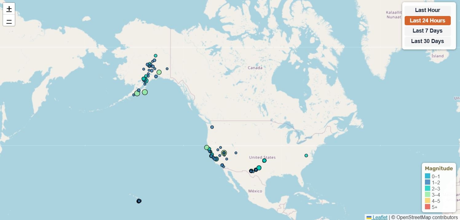
Coverage Notice: This map provides full U.S. seismic coverage. Border areas may appear on multiple regional maps to ensure no earthquake activity is missed. This overlap follows best practices in professional seismic monitoring. Note: This page updates on refresh. For the latest earthquake counts and statistics, please refresh the page.
📊 United States Earthquake Statistics
86 km SSW of Unalaska, Alaska
43 km NNW of Lake Minchumina, Alaska
43 km NNW of Lake Minchumina, Alaska
2025 Hubbard Glacier Earthquake
Magnitude 1.5+ • Data from USGS
🔔 Latest United States Earthquakes (M4.0+)
| Mag | Location | Date & Time | Depth |
|---|---|---|---|
| M4.10 | Rat Islands, Aleutian Islands, Alaska | Oct 17, 2026, 9:52 AM UTC | 94.7 km |
| M4.70 | 114 km SSW of Nikolski, Alaska | Oct 15, 2026, 1:16 PM UTC | 10.0 km |
| M5.60 | 43 km NNW of Lake Minchumina, Alaska | Oct 15, 2026, 11:07 AM UTC | 4.5 km |
| M4.60 | 194 km SE of Attu Station, Alaska | Oct 12, 2026, 2:29 PM UTC | 10.0 km |
| M4.40 | 275 km W of Adak, Alaska | Oct 11, 2026, 12:16 PM UTC | 95.2 km |
| M4.20 | 167 km S of Adak, Alaska | Oct 10, 2026, 12:30 PM UTC | 10.0 km |
| M4.00 | 245 km ESE of Attu Station, Alaska | Oct 8, 2026, 7:49 AM UTC | 10.0 km |
| M4.00 | Rat Islands, Aleutian Islands, Alaska | Oct 7, 2026, 8:47 AM UTC | 108.1 km |
| M5.50 | 92 km NNW of Aleneva, Alaska | Oct 6, 2026, 6:34 PM UTC | 87.6 km |
| M4.10 | 93 km SW of Atka, Alaska | Oct 3, 2026, 4:06 PM UTC | 50.3 km |
Updated: Oct 18, 2026, 9:53 PM UTC
United States Earthquake Maps by Region
The United States map above shows where recent earthquakes were recorded. The cards below are permanent navigation links rather than indicators of current activity. Open a page to view its latest available earthquake count, map, recent events and regional statistics.
- California experiences between 10,000 – 40,000 earthquakes per year, most too small to feel.
- Alaska produces more large earthquakes (M7+) than any other U.S. state, per decade.
- The Cascadia Subduction Zone is capable of generating megathrust earthquakes similar to Japan’s 2011 Tōhoku event.
About Earthquakes in the United States
The United States experiences more earthquakes than any other highly populated region, with thousands of events recorded annually. Most activity is concentrated along the Pacific Plate–North American Plate boundary, particularly in California, Alaska, and the Pacific Northwest. The U.S. Geological Survey (USGS) and regional seismic networks monitor nationwide earthquake activity 24/7.
Earthquake activity isn’t limited to the main Pacific Coast zones. You can also explore current earthquake activity in Hawaii, the Yellowstone region, the Central United States, and the Eastern United States.
Who Monitors Earthquakes in the U.S.?
The United States relies on several major scientific networks, including:
- USGS (U.S. Geological Survey) – National earthquake monitoring and hazard assessments.
- Caltech Seismological Laboratory – Research and seismic operations across Southern California.
- SCSN (Southern California Seismic Network) – High-resolution monitoring of California’s most active faults.
- CGS (California Geological Survey) – Fault mapping, hazard zones, and geologic analysis.
- ShakeAlert – Earthquake early warning system for the West Coast.
- MyShake App – Public early warning alerts and real-time reports.
Key U. S. Fault Zones
The most active and hazardous faults in the United States include:
- San Andreas Fault – Major strike-slip boundary between the Pacific and North American Plates.
- Hayward Fault and Calaveras Fault – Both faults connect so a rupture on one could easily trigger movement on the other.
- San Jacinto Fault – One of Southern California’s fastest-slipping faults.
- Garlock Fault – Important left-lateral fault across Southern California.
- Cascadia Subduction Zone – Capable of M8–M9 megathrust earthquakes.
- Mendocino Triple Junction – Intense seismic zone where three major plates meet.
Tectonic Setting
Earthquake activity in the United States is concentrated along the boundary between the Pacific Plate and North American Plate. The West Coast’s seismicity is mainly driven by California’s strike-slip faults, the subduction zone in Alaska, and the Cascadia megathrust in the Pacific Northwest (Washington and Oregon), resulting in one of the most active tectonic regions globally.
Notable United States Earthquakes
- 1906 San Francisco Earthquake – Devastating M7.9 rupture on the San Andreas Fault.
- 1989 Loma Prieta Earthquake – Major Bay Area shaking during the World Series – Major Bay Area shaking during the World Series.
- 1994 Northridge Earthquake – Destructive blind-thrust quake in Southern California.
- 2019 Ridgecrest Sequence – Large M6.4 and M7.1 ruptures in the Eastern California Shear Zone.
Earthquake Early Warning in the U.S.
The ShakeAlert system provides seconds of advance warning before shaking arrives, allowing people to quickly prepare. Alerts are delivered through mobile applications (the MyShake App) public systems, and institutional networks throughout California, Oregon, and Washington.
For more information, see our guide to the earthquake magnitude scale and our Earthquake Safety guide.
🗺️ Related Maps
View broader earthquake activity: Global Earthquakes | North America Earthquakes | Recent Earthquakes Worldwide
West Coast and Pacific: California | Alaska | Hawaii | Washington | Oregon
Interior West: Nevada | Utah | Idaho | Montana | Wyoming | Yellowstone
Central and Eastern U.S.: Central United States | Eastern United States