Northern California Earthquakes – Current Map & Latest Quakes
M2.80 10 km ESE of Gilroy, CA
6 hours ago · Depth 1.3 km
Recent Northern California Earthquakes (Past 24 Hours)
- M1.916 km NW of The Geysers, CA
- M2.8010 km ESE of Gilroy, CA
- M1.508 km NNW of Redwood Valley, CA
- M1.737 km ESE of Cloverdale, CA
- M1.9916 km S of Bridgeport, CA
- M2.032 km SW of Walker, CA
- M1.8112 km E of Coalinga, CA
- M1.9111 km ESE of Gilroy, CA
- M1.624 km ESE of Lake Pillsbury, CA
- M1.738 km ESE of Cloverdale, CA
- M1.6512 km ESE of Gilroy, CA
Source: USGS
Northern California is home to some of the most seismically active terrain in the continental United States. In and around the Bay Area, plate motion is distributed across major right-lateral faults such as the San Andreas, Hayward, Calaveras, Rodgers Creek, Concord-Green Valley, San Gregorio, and West Napa systems. Farther north, earthquake hazard is also shaped by the Mendocino Triple Junction and the southern Cascadia subduction zone.
Northern California Earthquake Map
This interactive map shows the latest earthquakes in Northern California including the San Francisco Bay Area, Sacramento region, Wine Country, the Central Coast, and the North Coast. Counts and lists update when the page loads or refreshes. Each colored circle represents an earthquake location. Click any circle to see details including magnitude, location, time, and depth. The map displays earthquakes of magnitude 1.5+. Use the time filter buttons to view earthquakes from the last hour, 24 hours, 7 days, or 30 days.
Northern California earthquakes (map loads with JavaScript)
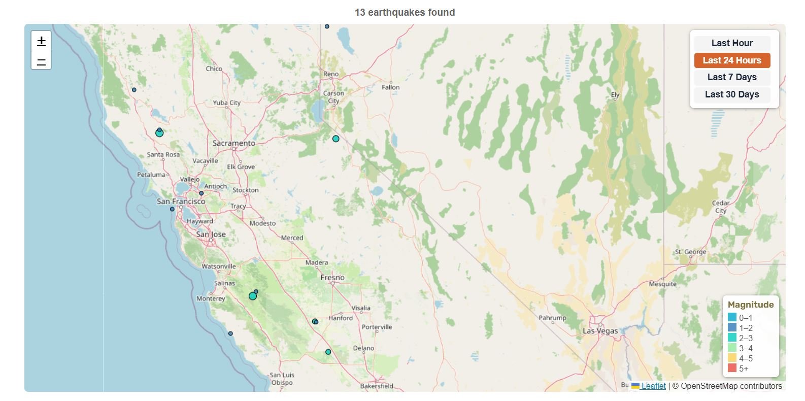
Magnitude
📊 Northern California Earthquake Statistics
10 km ESE of Gilroy, CA
8 km ESE of Cloverdale, CA
11 km N of Covelo, CA
11 km N of Redwood Valley, CA
Magnitude 1.5+ • Data from USGS
🔔 Latest Northern California Earthquakes (M4.0+)
| Mag | Location | Date & Time | Depth |
|---|---|---|---|
| M4.24 | 8 km ESE of Cloverdale, CA | Jul 29, 2026, 2:40 AM UTC | 5.9 km |
| M4.42 | 11 km N of Covelo, CA | Jul 11, 2026, 1:14 AM UTC | 10.3 km |
Updated: Jul 30, 2026, 8:30 PM UTC
The San Francisco Bay Area has its own dedicated page with focused coverage of the 9-county metro region including SF, Oakland, San Jose, and East Bay.
→ View Bay Area Earthquakes
About Northern California Earthquakes
The region sits along the active boundary between the Pacific Plate and the North American Plate, where these two massive tectonic plates slide sideways past one another in what scientists call right-lateral strike-slip motion. Much of this motion is taken up by the long network of faults that make up the San Andreas Fault system, which includes the Northern San Andreas as well as related strands like the Hayward and Calaveras faults that help distribute motion across the region (USGS active fault database).
North of Cape Mendocino, the tectonics become more complex at the Mendocino Triple Junction, where the Pacific, North American, and Gorda Plate (a fragment of the Juan de Fuca Plate) system meet and the plate motion transitions toward subduction. Offshore, the southern end of the Cascadia Subduction Zone frames another source of earthquake hazard along the North Coast as the Gorda Plate dives beneath the North American Plate. Together, these interacting plate boundaries and faults make Northern California one of the most seismically active regions in the continental United States.
Instrumental earthquake catalogs show frequent seismic activity across Northern California. In the greater Bay Area alone, there are on average 20 or more earthquakes per day, many too small or too deep to be felt. These catalogs help scientists identify active faults and assess where future earthquakes may occur. (USGS earthquake statistics).
Scientists use this extensive earthquake catalog together with geological fault maps and precise measurements of ground movement to assess future risk. UCERF3 provides authoritative long-term forecast models that incorporate these data to estimate how likely it is that a magnitude 6.7 or greater earthquake will occur on major California faults over the coming decades.
Source: USGS
Major Fault Systems in Northern California
- San Andreas Fault (Northern Section): Runs from near San Juan Bautista through the San Francisco Peninsula and north toward Cape Mendocino/Mendocino Triple Junction. The 1906 San Francisco earthquake ruptured about 296 miles / 477 km of the northern San Andreas and is generally described as an M7.8–7.9 quake.
- Hayward–Rodgers Creek System: The Hayward Fault runs through the densely populated East Bay, while the Rodgers Creek Fault extends north from San Pablo Bay through the Santa Rosa area. USGS-led research found the two faults are directly connected beneath San Pablo Bay, forming a roughly 118-mile / 190-km linked fault system capable of a combined rupture of about magnitude 7.4.
- Calaveras Fault: A major branch of the San Andreas fault system running through the Hollister and San Jose areas. It accommodates motion through both earthquakes and aseismic creep, especially near Hollister, and is capable of damaging M6.7+ earthquakes.
- Concord–Green Valley Fault System: A mostly right-lateral strike-slip fault system in the eastern Bay Area and adjacent North Bay, with documented creep especially along the Concord Fault. It’s capable of M6+ earthquakes and poses a risk to communities and infrastructure along the I-680/I-80 corridor, including transportation, water, and utility networks.
- San Gregorio Fault: A largely offshore fault system west of the San Andreas and one of the major earthquake sources on the western side of the Bay Area. It is capable of earthquakes exceeding magnitude 7.
- Maacama Fault: A major inland branch of the northern San Andreas fault system, extending through Sonoma and Mendocino counties, including areas near Ukiah and Willits. It shows documented creep and is an important North Coast seismic hazard.
- Greenville Fault: Runs through the Livermore Valley and eastern Bay Area and is an important inland source of East Bay earthquake hazard. USGS scenario material estimates the Greenville Fault has a maximum earthquake magnitude potential of about M6.9.
- Bartlett Springs Fault Zone: A major inland fault system in the Northern Coast Ranges and part of the broader northern San Andreas deformation zone. It is an active fault zone with evidence of recent movement and creep at depth, making it a regionally important contributor to Northern California seismic hazard.
- West Napa Fault: An important Wine Country fault and the source of the magnitude 6 South Napa earthquake on August 24, 2014. USGS describes the 2014 South Napa earthquake as the first Bay Area earthquake since the 1906 San Francisco earthquake to rupture the surface.
- Cascadia Subduction Zone: An offshore megathrust boundary extending from northern California/Cape Mendocino toward British Columbia/Vancouver Island. It is capable of M9 earthquakes and damaging tsunamis, making it the largest potential seismic source affecting far Northern California and the Pacific Northwest.
Seismically Active Regions
- Bay Area: San Francisco, Oakland, San Jose – crisscrossed by multiple active faults including San Andreas, Hayward, and Calaveras.
- Wine Country: Napa, Sonoma – affected by Rodgers Creek and West Napa faults.
- Sacramento Area: Capital region near multiple fault systems.
- North Coast: Mendocino Triple Junction where three tectonic plates meet.
- Santa Cruz and Monterey Bay: Active faults, including the San Andreas and related systems, contribute to earthquake activity around Santa Cruz, Monterey, and the surrounding coastal region.
Earthquake Risk & Probabilities in Northern California
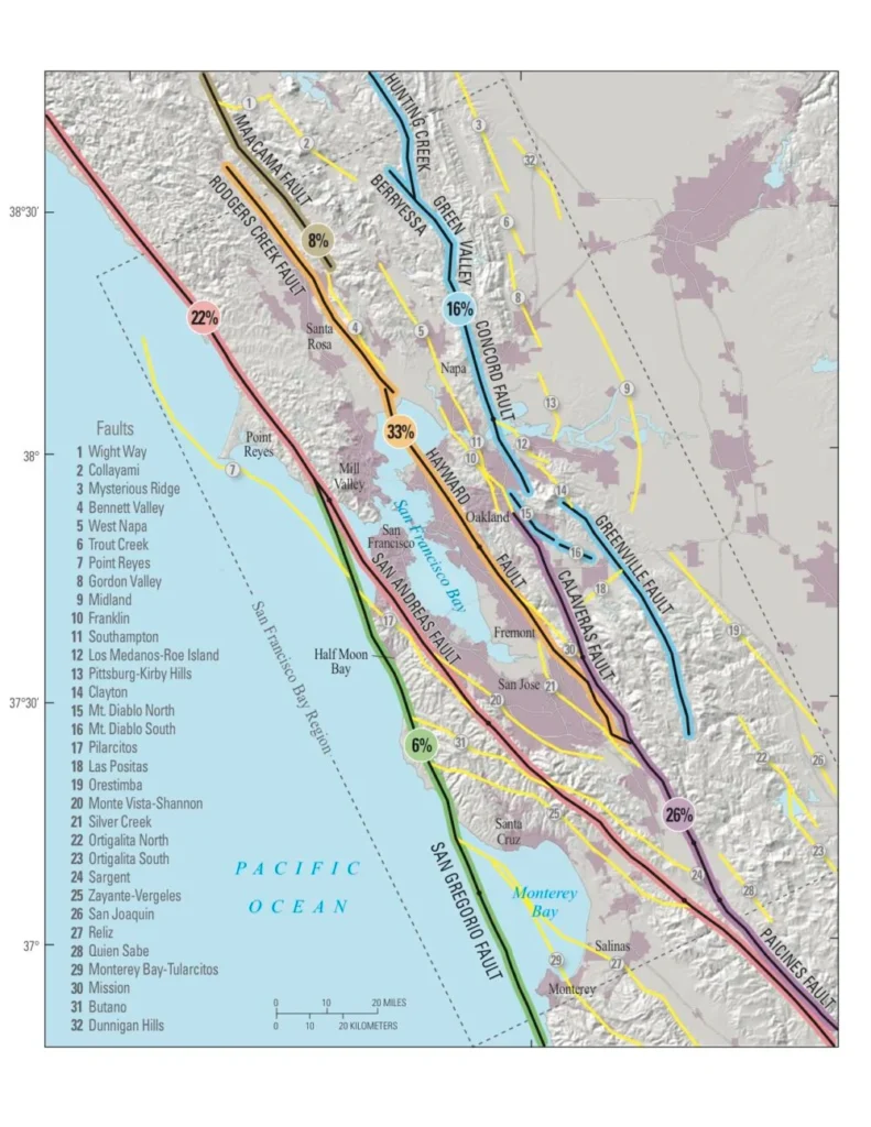
- Bay Area: According to UCERF3 (the current official California earthquake forecast published by USGS, CGS, and SCEC in 2013) there is approximately a 72% chance of a M6.7+ earthquake in the Bay Area by 2043.
- Hayward–Rodgers Creek Fault: Approximately 33% chance of a M6.7+ earthquake in the same 30-year window starting from 2014. The Hayward and Rodgers Creek faults are now confirmed to be physically connected, meaning a simultaneous rupture of the full combined system, roughly 118 miles long, is possible and could produce a M7.4 earthquake. (USGS)
- Cascadia Subduction Zone (offshore): Capable of rare M9+ megathrust earthquakes. While these events are infrequent, they pose a significant long term risk to the broader Pacific Northwest including parts of Northern California.
- San Andreas Fault (Northern Section): Produced the 1906 San Francisco earthquake (M7.9) and remains capable of major M7+ surface-rupturing earthquakes.
- Wine Country: The West Napa Fault was responsible for the magnitude 6 South Napa earthquake in August 2014, highlighting that damaging earthquakes can occur on smaller, less well-known faults.
- Sacramento Region: Often considered lower risk than coastal areas, but not risk-free. The Sacramento–San Joaquin Delta includes lesser-known faults such as the Midland Fault Zone and West Tracy Fault, and its soft, water-saturated soils can increase the potential for infrastructure damage during strong shaking, especially to levees, bridges, pipelines, and other lifeline systems.
Historical Major Earthquakes in Northern California
- 1868 Hayward (M6.8–7.0): A major rupture of the southern Hayward Fault caused severe damage across East Bay communities and remains a key planning scenario due to today’s dense population along the fault.
- 1906 San Francisco (M7.9): Ruptured approximately 296 miles (477 km) of the northern San Andreas Fault from San Juan Bautista to Cape Mendocino, triggering extreme shaking and fires that destroyed much of San Francisco, killed over 3,000 people, and left hundreds of thousands homeless. USGS geodetic modelling confirms the preferred moment magnitude as Mw 7.9.
- 1989 Loma Prieta (M6.9): Struck the Santa Cruz Mountains during the World Series, killing 63 people, collapsing major structures, and accelerating seismic retrofits across the Bay Area.
- 1992 Cape Mendocino (M7.2): A powerful offshore earthquake near the North Coast that triggered landslides and highlighted the combined hazard from crustal faults and Cascadia-related tectonics.
- 2014 South Napa (M6.0): Ruptured the West Napa Fault, damaging buildings and infrastructure in Napa Valley and highlighting the vulnerability of older masonry structures in Wine Country.
Earthquake Preparedness
California as a whole maintains statewide building standards under Title 24 (Part 2), regulatory zoning for surface fault rupture (Alquist-Priolo Act) and liquefaction/landslides (Seismic Hazards Mapping Act), and ShakeAlert-powered public warnings delivered via Wireless Emergency Alerts (WEA), the MyShake app, and Android built-in alerts.
Earthquake Safety Checklist
- Keep a 3-day supply of food, water, and medications
- Secure heavy furniture and appliances
- Know “Drop, Cover, and Hold On” procedures
- Download the MyShake app and make sure Wireless Emergency Alerts are enabled on your phone. Android users can also enable Android Earthquake Alerts. ShakeAlert is the USGS-managed detection system that helps power these public alerts.
- Have an out-of-area emergency contact
Several faults in Northern California, including parts of the Hayward and Calaveras faults, experience slow fault creep where the ground moves gradually without producing large earthquakes. This process can reduce stress in some fault segments while transferring it to others.
Source: USGS
Northern California’s Earthquake Monitoring Networks
Northern California’s earthquake monitoring data comes from several scientific networks working together:
- USGS Earthquake Hazards Program – national seismic monitoring and hazard assessment.
- Berkeley Seismological Laboratory – partners with USGS on Northern California seismic monitoring.
- USGS Menlo Park – monitors Northern California seismicity and supports ShakeAlert.
- California Geological Survey (CGS) – provides fault maps and seismic hazard zoning.
🗺️ Related Maps
View California regions: Southern California | San Francisco Bay Area | California
View broader region: United States Earthquakes | North America
View other states: Alaska | Washington
More resources: See all recent earthquakes globally | Earthquake Warning California | USGS Earthquake Hazards Program
[eww_region_health region=”northern-california”]