
Oregon Earthquakes
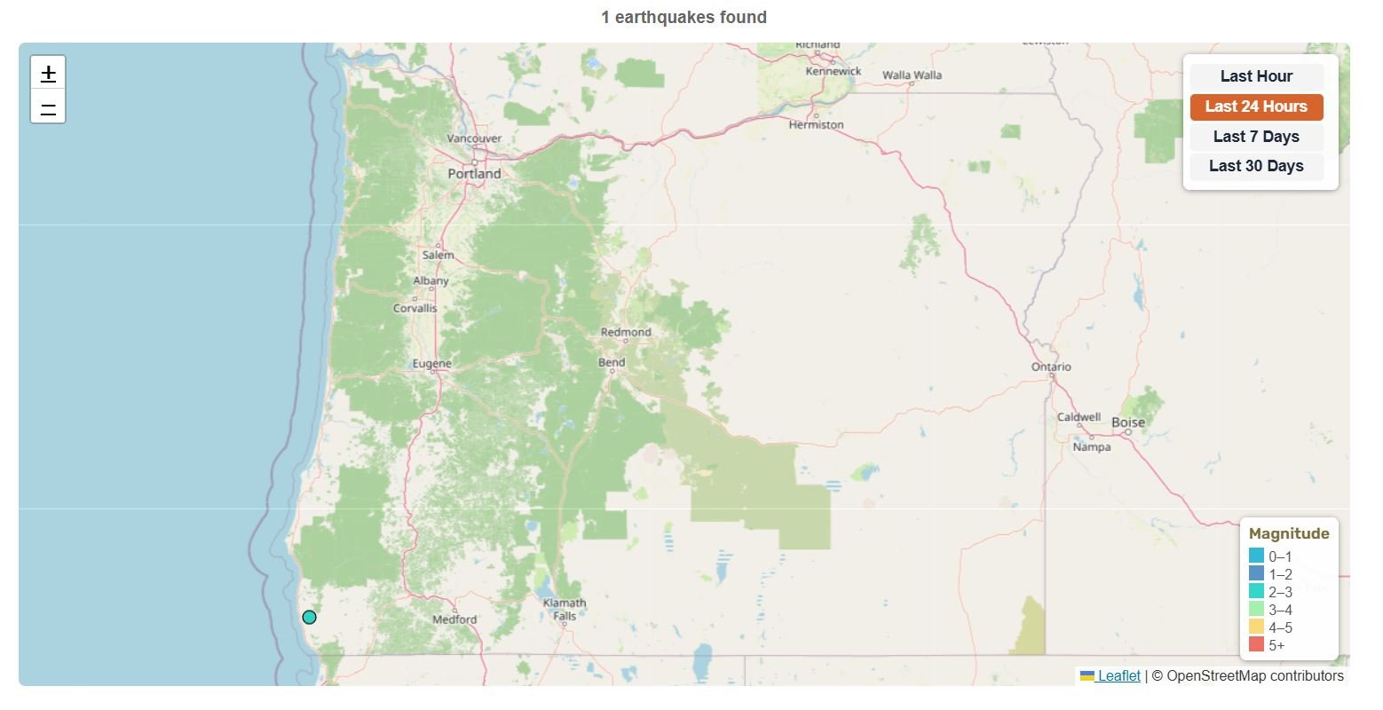
M2.26 5 km ENE of Medford, Oregon
22 hours ago · Depth -1.5 km
Recent Oregon Earthquakes (Past 24 Hours)
- M2.265 km ENE of Medford, Oregon
Source: USGS
Track the latest available earthquake activity in Oregon using USGS data. The map, statistics, significant quake table, and recent earthquake list update when the page loads or refreshes.
Oregon is one of the most important earthquake regions in the United States because it sits above the Cascadia Subduction Zone, has active crustal faults near major population centers, and contains Cascade volcanoes that can produce small earthquake swarms.
The interactive map shows M1.5+ earthquakes in Oregon. Each colored circle represents an earthquake location. Click any circle to see magnitude, location, time, and depth. Use the time filter buttons to view earthquakes from the last hour, 24 hours, 7 days, or 30 days.
Current Oregon Earthquake Map
📊 Oregon Earthquake Statistics
5 km ENE of Medford, Oregon
5 km ENE of Medford, Oregon
188 km W of Bandon, Oregon
off the coast of Oregon
Magnitude 1.5+ • Data from USGS
🔔 Latest Oregon Earthquakes (M4.0+)
No M4.0+ earthquakes in the last 30 days
Updated: Oct 14, 2026, 10:16 PM UTC
About Oregon Earthquakes
Oregon’s earthquake risk comes from several different sources. The most important is the Cascadia Subduction Zone, an offshore fault system where the Juan de Fuca Plate is being pushed beneath the North American Plate. This is the same subduction zone that affects Washington earthquakes and the broader Pacific Northwest.
Oregon also has shallow crustal faults, especially around the Portland metro area, the Willamette Valley, and parts of southern Oregon. These earthquakes are usually smaller than a Cascadia megathrust earthquake, but they can still be damaging when they happen close to cities.
A third source is volcanic and tectonic seismicity around the Oregon Cascades. Volcanoes such as Mount Hood, Three Sisters, Newberry Volcano, Crater Lake/Mount Mazama, and Mount Jefferson can produce small earthquakes as rock, fluids, gases, or magma move underground.
Oregon’s earthquake risk is not only a coastal issue. Strong shaking from a major Cascadia earthquake could affect inland communities too, including the Willamette Valley and Portland metro area.
The Three Main Types of Oregon Earthquakes
Oregon’s earthquake risk is easier to understand when it’s grouped into three main categories: Cascadia megathrust earthquakes, shallow crustal earthquakes, and earthquake activity linked to deep intraslab movement or Cascade volcanoes.
Cascadia Megathrust Earthquakes
Cascadia megathrust earthquakes happen offshore, where the Juan de Fuca Plate is being pushed beneath the North American Plate. The Cascadia Subduction Zone stretches from Northern California to British Columbia in Canada, passing offshore of Oregon and Washington.
This is Oregon’s largest earthquake and tsunami hazard. A full-margin Cascadia rupture could produce an earthquake around M9, with strong shaking lasting several minutes near the coast. Oregon Emergency Management describes the Oregon coast as having the potential for five to seven minutes of shaking or rolling during a major Cascadia earthquake, with shaking generally decreasing farther inland.
The last known full-margin Cascadia earthquake happened on January 26, 1700. A USGS Professional Paper on the orphan tsunami of 1700 explains how Japanese historical records helped scientists confirm the timing of that event.
Not every Cascadia earthquake has to rupture the entire fault at once. Scientists also recognize partial-margin ruptures, where only part of the subduction zone breaks. These can still be very large earthquakes of around M8 or higher, and they can still produce damaging shaking or tsunami hazard along part of the coast.
A useful way to explain the risk is this: a full-margin M9 Cascadia earthquake is possible, but partial-margin earthquakes may be more likely. PNSN describes evidence for both full-margin ruptures around magnitude 9 and partial-margin ruptures around M8. The 2025 USGS Pacific Northwest hazard update estimates roughly a 30% chance of an M8+ earthquake in southern Cascadia in the next 50 years, while PNSN notes a 10–15% chance of a full-margin approximately M9 Cascadia earthquake over the same period.
Shallow Crustal Earthquakes
Shallow crustal earthquakes happen on faults within Oregon’s upper crust. These can be especially damaging when they happen close to cities because the shaking begins near the surface and near buildings, roads, bridges, utilities, and people.
Important crustal fault areas in Oregon include the Portland Hills Fault, the Gales Creek–Mount Angel fault zone, faults around the Willamette Valley, and faults in southern Oregon near Klamath Falls. The 1993 Scotts Mills earthquake is one example of a damaging crustal earthquake in western Oregon. The Pacific Northwest Seismic Network records it as a magnitude 5.6 event that produced strong local shaking and was widely felt across western Oregon.
These earthquakes are smaller than an M9 Cascadia event, but they matter because they can happen directly under or near populated areas.
Volcanic and Deep Intraslab Earthquakes
Oregon also has earthquake activity around the Cascade Range. Small earthquake swarms can happen near volcanoes such as Mount Hood, Three Sisters, Newberry Volcano, Crater Lake/Mount Mazama, and Mount Jefferson. These swarms do not automatically mean an eruption is coming, but they are signs scientists watch when checking for changes underground.
The USGS Cascades Volcano Observatory monitors volcanoes across the Cascade Range, including Oregon volcanoes. Changes in earthquake patterns, ground movement, gas emissions, and other signals can help scientists understand what may be happening below the surface.
Oregon can also feel deeper earthquakes related to the subducting Juan de Fuca Plate. These deep intraslab earthquakes happen inside the plate as it bends and sinks beneath the Pacific Northwest. They are more prominent in Washington, but they are still part of the broader Cascadia subduction system.
Major Oregon Earthquake Hazards
The main hazards below explain where Oregon’s earthquake risk comes from and why the impacts can vary so much by location.
- Cascadia Subduction Zone: Oregon’s largest earthquake and tsunami hazard. A full-margin Cascadia rupture could reach about magnitude 9, while partial-margin ruptures around magnitude 8 can still be very large and damaging.
- Portland Hills Fault: A mapped crustal fault zone near Oregon’s largest metro area. Even a moderate local earthquake near Portland could be disruptive because of population density, older buildings, bridges, utilities, and soft soils in some areas.
- Gales Creek–Mount Angel fault zone: A western Oregon fault system that matters for the Portland region, Willamette Valley, and surrounding communities.
- Oregon Coast: The coast is closest to the Cascadia Subduction Zone and has the state’s highest tsunami risk. Strong or long shaking near the coast is a natural warning to move to high ground after the shaking stops.
- Klamath Falls area: Southern Oregon has experienced damaging shallow earthquakes, including the 1993 Klamath Falls sequence.
- Cascade volcanoes: Mount Hood, Three Sisters, Newberry Volcano, Crater Lake/Mount Mazama, and Mount Jefferson can produce earthquake swarms linked to volcanic, hydrothermal, or tectonic activity.
- Deep intraslab earthquakes: These happen within the subducting Juan de Fuca Plate, usually tens of kilometers below the surface. They are more common in Washington, but they are still part of the broader Cascadia system.
- Liquefaction and soft soils: Loose or water-saturated ground can lose strength during strong shaking, damaging roads, foundations, buried pipes, waterfront areas, and port facilities.
Seismically Active Areas in Oregon
Earthquake risk is not the same everywhere in Oregon. The coast, Portland metro area, Willamette Valley, Cascade Range, and southern Oregon each face different combinations of shaking, tsunami, fault, volcanic, and infrastructure hazards.
- Oregon Coast: Coastal communities such as Seaside, Cannon Beach, Newport, Lincoln City, Coos Bay, Bandon, and Brookings are closest to the Cascadia Subduction Zone and need to treat tsunami evacuation as a core safety issue.
- Portland Metro: Portland is farther from the offshore Cascadia fault, but it has high population exposure, older buildings, bridges, utilities, soft soils, and nearby crustal faults. That makes earthquake planning important even away from the coast.
- Willamette Valley: Salem, Eugene, Corvallis, Albany, and surrounding communities can be affected by Cascadia shaking and by local crustal earthquakes. The valley also contains major transportation routes, schools, hospitals, and utilities.
- Cascade Range: Mount Hood, Mount Jefferson, Three Sisters, Newberry Volcano, and Crater Lake/Mount Mazama can produce small earthquakes and earthquake swarms. These are usually not dangerous by themselves, but scientists watch changes in earthquake patterns around volcanic systems.
- Klamath Falls and southern Oregon: This is one of Oregon’s most important inland earthquake areas. The 1993 Klamath Falls earthquakes showed that damaging earthquakes can happen well away from the coast.
- Offshore Oregon and the Blanco Fracture Zone: Not every offshore earthquake is a Cascadia megathrust event. Some offshore earthquakes occur on nearby fault systems such as the Blanco Fracture Zone and may be felt along the coast without being part of a Cascadia rupture.
🗺️ Related Maps
Compare Oregon with nearby and related earthquake regions, including:
North America | United States | Washington | Idaho | Northern California | Canada.
You can also view the list of earthquakes today worldwide.
Infrastructure, Liquefaction, and Recovery Risk
Oregon’s earthquake risk is not only about the size of the earthquake. It is also about what the shaking hits.
Many parts of western Oregon have older buildings, bridges, utilities, and soft or water-saturated soils. During strong shaking, those soils can lose strength through liquefaction, which can damage foundations, roads, buried pipes, waterfronts, and port facilities.
Western Oregon has many of the state’s largest population centers, transportation routes, hospitals, utilities, and emergency services. A major Cascadia earthquake could disrupt roads, bridges, power, water, communications, fuel supply, and emergency access across a wide area.
The Oregon Resilience Plan warns that some services and infrastructure could take a long time to recover. For Portland and the Willamette Valley, the main risks are shaking, liquefaction, landslides, bridge and building damage, and disruption to lifelines, not tsunami risk.
Many Oregon earthquake hazards come from the ground beneath communities, not just the earthquake source itself. Soft soils, filled land, river valleys, and waterfront areas can shake more strongly than nearby bedrock during the same earthquake.
Oregon Coast Earthquakes and Tsunami Risk
For the Oregon coast, earthquake safety and tsunami safety go together.
If a large Cascadia earthquake happens offshore, coastal communities may feel strong or long shaking before any official alert arrives. That shaking is a natural warning. If you are on the Oregon coast and feel strong or long shaking, move to high ground after the shaking stops. Do not wait for a siren if the natural warning signs are obvious. A local tsunami could reach parts of the coast within minutes, so knowing your evacuation route before an earthquake happens is essential.
This is why Oregon’s coast has tsunami evacuation routes, assembly areas, and hazard maps for coastal communities. Coastal residents and visitors should know whether they are in a tsunami zone before an earthquake happens.
Another coastal concern is sudden land subsidence. A major Cascadia earthquake can cause parts of the coast to drop, which may increase flooding and make recovery harder after the shaking and tsunami threat have passed.
Oregon’s Cascade Volcanoes and Earthquakes
Oregon’s Cascade volcanoes are another important part of the state’s earthquake story.
Mount Hood is the best-known Oregon volcano because it is close to Portland and has nearby communities, roads, and recreation areas. Small earthquakes around Mount Hood can be linked to volcanic, hydrothermal, or tectonic processes.
The Three Sisters region is also closely watched. Earthquake swarms and ground deformation in the central Oregon Cascades can help scientists understand changes underground.
Newberry Volcano, southeast of Bend, is another major volcanic center. Crater Lake sits in the remains of Mount Mazama, one of the most important volcanic systems in Oregon’s geologic history.
Most volcanic earthquakes are small. A swarm does not automatically mean an eruption is coming. It means scientists are watching the pattern, location, depth, and timing of the earthquakes to understand what may be changing.
The USGS Cascades Volcano Observatory monitors volcanoes across the Cascade Range, including Oregon volcanoes such as Mount Hood, Three Sisters, Newberry Volcano, Crater Lake/Mount Mazama, and Mount Jefferson.
Historical Oregon Earthquakes
Oregon has experienced several important earthquakes, including offshore Cascadia events, shallow crustal earthquakes, and damaging southern Oregon quakes.
- 1700 Cascadia (M8.7-M9.2): The last known full-margin rupture of the Cascadia Subduction Zone. It generated a trans-Pacific tsunami that was recorded in Japanese historical documents.
- 1873 North Central Oregon (M6.0-6.8): Exact location uncertain and estimates vary because it happened before modern instruments were used.
- 1993 Scotts Mills (M5.6): Northwest Oregon. It damaged schools and historic buildings and was felt across much of western Oregon. PNSN describes it as the largest earthquake in the Pacific Northwest since 1981 at the time it occurred.
- 1993 Klamath Falls (M5.9 & M6.0): Among Oregon’s most damaging modern earthquakes. A magnitude 5.9 event was followed by a magnitude 6.0 event the same evening, with thousands of aftershocks in the months that followed.
- 2024 Offshore Oregon earthquake, M6.0: A strong earthquake occurred about 267 km west of Bandon, Oregon, on October 30, 2024. The USGS event page lists it as a reviewed M6.0 earthquake at a depth of 10.0 km.
Not Every Oregon Earthquake Is a Cascadia Earthquake
Because Cascadia gets so much attention, it is easy to assume every Oregon earthquake is connected to the offshore subduction zone. That is not the case.
A small earthquake near Mount Hood or Three Sisters may be related to volcanic or local tectonic activity. A shallow earthquake near Klamath Falls may come from crustal faulting in southern Oregon. An offshore earthquake may happen on the Blanco Fracture Zone rather than the Cascadia megathrust.
Location and depth matter. A shallow earthquake near a city can cause stronger local shaking than a deeper event of similar magnitude. A large offshore Cascadia earthquake creates a different concern again: long-duration shaking and tsunami risk for the Oregon coast.
The main takeaway is simple: Cascadia is Oregon’s largest earthquake hazard, but it is not Oregon’s only earthquake hazard.
Earthquake Preparedness
Oregon is part of the ShakeAlert earthquake early warning system and maintains tsunami evacuation planning for coastal communities. A major Cascadia event could cause widespread, long-term disruptions, so coastal residents and visitors should know their tsunami evacuation routes before an earthquake happens.
ShakeAlert can provide seconds of warning in some situations, but it cannot predict earthquakes and it may not provide warning for people very close to the epicenter.
Earthquake Safety Checklist
- Keep emergency supplies, including food, water, medications, lights, batteries, and first-aid items. A major Cascadia event could cause extended disruptions.
- Secure heavy furniture, water heaters, and propane tanks.
- Know “Drop, Cover, and Hold On” procedures.
- Set up ShakeAlert-powered alerts through Wireless Emergency Alerts, Android’s built-in earthquake alerts, or the MyShake app where available.
- If you are on the coast, know your tsunami evacuation route and practice reaching high ground or an assembly area quickly.
- Participate in the annual Great Oregon ShakeOut drill.
- Keep important documents and emergency supplies in waterproof containers.
- Sign up for local emergency alerts through OR-Alert if available in your area.
For more guidance, see our Earthquake Safety guide for what to do during shaking and our Earthquake Preparedness guide for emergency supplies and planning ahead.
Oregon Emergency Management describes a major Cascadia earthquake as capable of about five to seven minutes of shaking or rolling along the coast, followed by tsunami danger in coastal areas.
Source: Oregon Emergency Management
How Oregon Earthquakes Are Monitored
Oregon earthquake activity is monitored by the Pacific Northwest Seismic Network, the USGS Earthquake Hazards Program, the Oregon Department of Geology and Mineral Industries, and the Oregon Department of Emergency Management.
These organizations provide earthquake data, seismic monitoring, hazard maps, tsunami evacuation information, and public safety guidance.
The earthquake map and statistics on this page are based on USGS earthquake data filtered for Oregon. They update when the page loads or refreshes.