Southern California Earthquakes – Current Map & Latest Quakes
M2.44 3 km NE of Long Beach, CA
11 hours ago · Depth 14.5 km
Recent Southern California Earthquakes (Past 24 Hours)
- M1.547 km SSE of Home Gardens, CA
- M2.293 km S of Lakewood, CA
- M1.7116 km SW of Lamont, CA
- M2.443 km NE of Long Beach, CA
- M1.7617 km WSW of Johannesburg, CA
- M1.505 km S of Encino, CA
Source: USGS
Southern California is one of the most seismically active regions in the United States, home to major fault systems including the San Andreas Fault, San Jacinto Fault, and Elsinore Fault. The Los Angeles metropolitan area, San Diego, Orange County, and the Inland Empire all face ongoing earthquake hazard due to the region’s complex network of active faults. This page displays the latest earthquake data for Southern California using USGS earthquake information.
Southern California Earthquake Map
This interactive map shows recent earthquakes of magnitude 1.5+ in Southern California, including the Los Angeles Basin, San Diego region, Orange County, the Inland Empire, and Imperial Valley, using USGS earthquake data. Counts and lists update when the page loads or refreshes. Each colored circle represents an earthquake location. Click any circle to see details including magnitude, location, time, and depth. Use the time filter buttons to view earthquakes from the last hour, 24 hours, 7 days, or 30 days.
Southern California earthquakes (map loads with JavaScript)
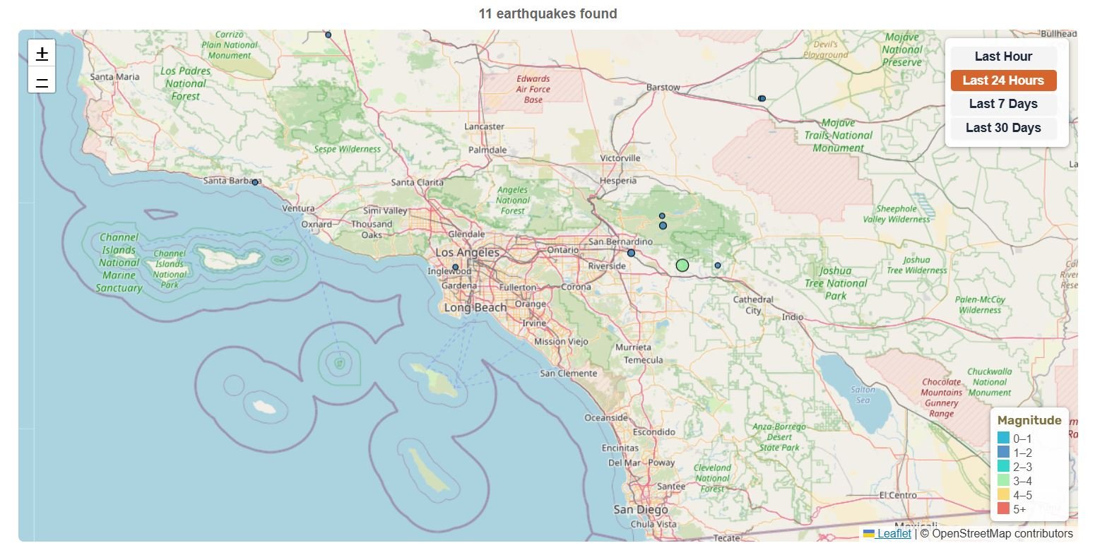
Magnitude
Source: USGS
About Southern California Earthquakes
📊 Southern California Earthquake Statistics
3 km NE of Long Beach, CA
10 km SW of Niland, CA
18 km WSW of Johannesburg, CA
20 km NNE of Indio, CA
Magnitude 1.5+ • Data from USGS
🔔 Latest Southern California Earthquakes (M4.0+)
| Mag | Location | Date & Time | Depth |
|---|---|---|---|
| M4.32 | 18 km WSW of Johannesburg, CA | Jul 13, 2026, 4:40 PM UTC | 7.6 km |
| M4.11 | 2 km ESE of Frazier Park, CA | Jul 12, 2026, 10:38 AM UTC | 13.1 km |
Updated: Jul 30, 2026, 9:17 PM UTC
Southern California is one of the most earthquake-prone and heavily populated regions in the United States. The San Andreas Fault system runs through Southern California and is capable of producing a M8+ earthquake. The 1994 Northridge earthquake (M6.7) remains one of the costliest natural disasters in U.S. history. With Los Angeles, San Diego, Orange County, and the Inland Empire all close to active faults, millions of people live in areas where damaging earthquakes are a real concern.
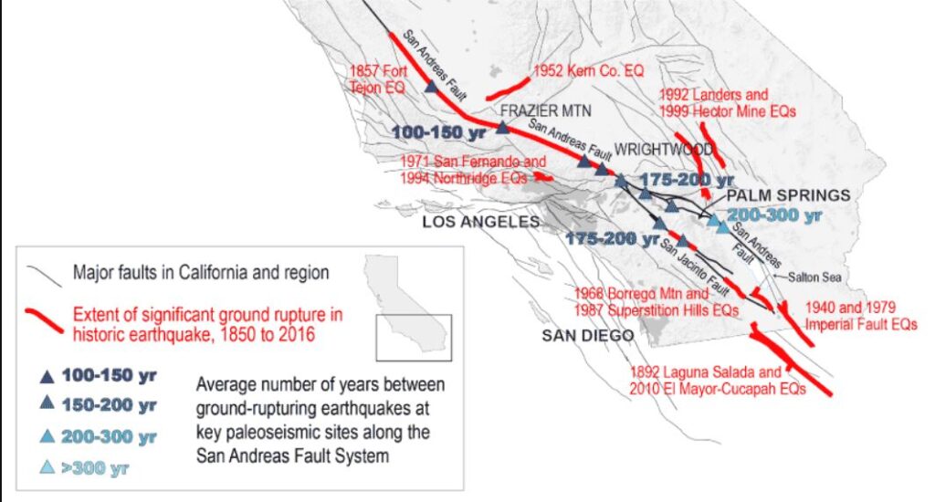
Major Fault Systems in Southern California
Southern California’s earthquake hazard stems from multiple active fault systems that accommodate motion between the Pacific and North American tectonic plates. (USGS)
- San Andreas Fault (Southern Section): Runs along the eastern side of the Los Angeles region toward the Coachella Valley and Salton Sea. Capable of M8.0+ earthquakes (USGS)
- San Jacinto Fault: Major fault zone through Riverside and San Bernardino counties, one of the most active faults in Southern California (UCSD).
- Elsinore Fault: Extends from the Mexican border through Lake Elsinore to Corona, capable of M7.0+ earthquakes (SCEDC).
- Newport-Inglewood Fault: Runs through densely populated areas of Los Angeles and Orange County, responsible for the 1933 Long Beach earthquake.
- Whittier Fault: A major East Los Angeles fault capable of M6.0–7.2 earthquakes (SCEDC).
- Palos Verdes Fault: Recent scenario-based modelling suggests that a linked offshore rupture involving the Palos Verdes system could approach M7.8 that could significantly impact the L.A. coastline and the ports of Los Angeles and Long Beach.
- Rose Canyon Fault: Runs through downtown San Diego and continues offshore. Recent studies have highlighted its potential for surface-rupturing earthquakes.
- Sierra Madre Fault: Northern Los Angeles basin, capable of M7.0+ earthquakes (SCEDC)
- Puente Hills Blind Thrust Fault: A buried thrust fault system beneath the Los Angeles Basin, including areas near downtown Los Angeles. Because it does not visibly break the surface, it is less obvious than faults like the San Andreas, but USGS loss-estimate work shows that a major Puente Hills earthquake could produce severe regional impacts.
- Garlock Fault: A major left-lateral fault along the northern edge of the Mojave Desert, separating the Mojave block from the southern Sierra Nevada and Basin and Range region. It is an important part of Southern California’s broader fault network, even though it is less directly tied to Los Angeles urban shaking than the faults beneath the basin.
- Ventura–Pitas Point Thrust System: A major compressional fault system in the Ventura region, part of the complex Transverse Ranges. These thrust and reverse faults contribute to earthquake hazard along the Ventura and Santa Barbara coast.
- Imperial Fault and Brawley Seismic Zone: Active faults in the Imperial Valley near the southern end of the San Andreas system. This region frequently produces earthquake swarms and moderate earthquakes and is an important transition zone between the San Andreas system and faults farther south.
Secondary Earthquake Hazards in Southern California
Strong shaking is not the only earthquake hazard in Southern California. Basin areas with soft sediments can amplify shaking, coastal and hillside areas may face landslides, and low-lying coastal zones can be vulnerable to liquefaction or tsunami hazards from offshore earthquakes. Older unreinforced masonry buildings, soft-story buildings, bridges, aqueducts, ports, pipelines, and transportation corridors can also be vulnerable during strong shaking.
Seismically Active Regions in Southern California
Southern California’s seismic activity is concentrated in several key regions where tectonic stress accumulates along active fault systems:
- Los Angeles Basin: One of the most densely populated seismically active regions in the world, with over 10 million people living above and near active faults including the Newport-Inglewood and Palos Verdes strike-slip systems, and the Puente Hills blind thrust fault, which is particularly significant as it lies directly beneath densely populated areas and is often cited as a “worst-case” scenario for the city.
- San Bernardino and Riverside (Inland Empire): Located between and very near the San Andreas and San Jacinto fault zones, this rapidly growing region faces high earthquake risk from multiple active fault systems.
- Coachella Valley and Imperial Valley: The southern onshore terminus of the San Andreas Fault in the Coachella Valley transitions into the Imperial Valley, which has high slip rates and moderate earthquakes and is capable of M7.0+ events.
- San Diego Region: Though generally less active than Los Angeles, San Diego faces significant earthquake hazard from the Rose Canyon Fault Zone, which runs through the urban core and continues offshore. Because parts of the fault pass through densely developed areas, even a moderate to strong earthquake could have serious impacts locally.
- Ventura and Santa Barbara: The Transverse Ranges host complex thrust and reverse faults that can produce damaging earthquakes. The region has experienced several destructive earthquakes in the past.
- Mojave Desert and Eastern California Shear Zone: East of the San Andreas Fault, this region accommodates significant tectonic motion through distributed faulting. This zone includes the major Garlock Fault and was the location of the 2019 Ridgecrest earthquakes, including the M7.1 event.
Earthquake Risk & Probabilities in Southern California
Scientific probability estimates provide critical information for earthquake preparedness and building code development. The following are 30-Year Earthquake Probabilities (Based on UCERF3):
- Southern California has a 37% chance of one or more M7.5+ earthquakes occurring by 2043.
- According to UCERF3 — the current official California earthquake rupture forecast, (published in 2013–2015 by USGS, CGS, and SCEC) the Los Angeles region has a 60% chance of experiencing a M6.7+ earthquake during the 30-year period from 2014 to 2043.
- UCERF3 estimates fewer M6.7+ earthquakes on the San Jacinto Fault than earlier models because some rupture probability is now assigned to rare, much larger multi-fault earthquakes. (USGS)
UCERF3 provides authoritative long-term earthquake probabilities that inform California’s seismic hazard maps, which in turn underpin the state’s building codes and emergency planning standards. (USGS Open-File Report: UCERF3).
Historical Major Earthquakes in Southern California
- 1857 Fort Tejon Earthquake (M7.9): One of the largest historical earthquakes in California, this event ruptured a long section of the San Andreas Fault from near Parkfield southeast toward the Wrightwood/Cajon Pass area. It occurred when the region was sparsely populated but produced major surface rupture and large offsets along the fault.
- 1933 Long Beach Earthquake (M6.4): Newport-Inglewood Fault quake caused 115-120 deaths, $40 million in damage (1933 dollars). Destroyed over 230 school buildings, helped lead to California’s Field Act, which imposed state-supervised earthquake-resistant school construction.
- 1952 Kern County Earthquake (M7.5): White Wolf Fault quake caused 12 deaths, $60 million in damage (1952 dollars). One of the largest earthquakes recorded in California since the 1906 quake in San Francisco.
- 1971 San Fernando (Sylmar) Earthquake (M6.6): the San Fernando Fault Zone (Sierra Madre system) quake led to 64 deaths and over $505 million in damage. Nearly collapsed the Lower Van Norman Dam, requiring evacuation of 80,000 people. Led to major revisions in hospital and infrastructure building codes.
- 1987 Whittier Narrows Earthquake (M5.9): the Puente Hills blind thrust fault quake caused significant damage to older unreinforced masonry buildings.
- 1992 Landers Earthquake (M7.3): multiple faults in Eastern California Shear Zone. Official California summaries list one death, about 400 injuries, and about $9.1 million in damage. Triggered earthquakes throughout Southern California.
- 1994 Northridge Earthquake (M6.7): Northridge blind thrust fault caused multiple deaths, thousands of injuries, $20 billion in damage, $40+ billion in economic loss. The costliest earthquake in U.S. history. Exposed vulnerabilities in steel-frame buildings and prompted major code revisions.
- 1999 Hector Mine Earthquake (M7.1): A major Mojave Desert earthquake that ruptured faults within the Eastern California Shear Zone. It caused limited damage because of its remote location but remains one of the largest Southern California earthquakes of the modern instrumental era.
- 2019 Ridgecrest Earthquake Sequence (M6.4, M7.1): A major earthquake sequence in the Eastern California Shear Zone near Ridgecrest, China Lake, and Trona. The sequence included a M6.4 foreshock on July 4 and a M7.1 mainshock on July 5, rupturing multiple faults and causing significant local damage.
🗺️ Related Earthquake Maps
View California regions: Northern California | San Francisco Bay Area | California
View broader region: United States Earthquakes | North America
View other states: Alaska | Washington
More resources: See all recent earthquakes globally | Earthquake Warning California | USGS Earthquake Hazards Program
Southern California’s Earthquake Monitoring Networks
Southern California is monitored by a large network of seismic stations that help detect earthquakes quickly, support public alerts, and provide data for scientists studying the region’s earthquake activity.
- Southern California Seismic Network (SCSN) – Operates hundreds of seismic stations across Southern California. Detects and locates earthquakes annually and provides rapid earthquake information.
- California Integrated Seismic Network (CISN) – Integrates Northern and Southern California seismic networks to provide unified earthquake monitoring for the entire state. Produces ShakeMaps, earthquake notifications, and coordinates emergency response.
- ShakeAlert Earthquake Early Warning System – managed by the U.S. Geological Survey. Detects significant earthquakes and alerts people and automated systems seconds before strong shaking begins.
- MyShake App – Developed by UC Berkeley in partnership with USGS ShakeAlert and Cal OES, the app provides earthquake early warnings by alerting smartphone users near an event as soon as ground sensors detect strong shaking.
Earthquake Preparedness
All California residents should have emergency kits and family disaster plans.
Earthquake Safety Checklist
- Keep a 3-day go-bag and larger household/work supplies for several days to up to 2 weeks, depending on circumstances.
- Secure heavy furniture and appliances
- Know “Drop, Cover, and Hold On” procedures
- Download the MyShake App and make sure Wireless Emergency Alerts are enabled on your phone. Android users can also enable Android Earthquake Alerts. ShakeAlert is the USGS-managed detection system that helps power these public alerts.
- Have an out-of-area emergency contact
FAQs – Earthquakes in Southern California
Why is Southern California so seismically active?
Southern California sits on the boundary between the Pacific and North American tectonic plates. The San Andreas Fault and numerous related fault systems create one of the most seismically active regions in North America, with thousands of earthquakes occurring annually.
What was the 1994 Northridge earthquake?
The 1994 Northridge earthquake was a magnitude 6.7 earthquake that struck on January 17, 1994. It caused 57 deaths, over 9,000 injuries, and more than $20 billion in damage, making it one of the costliest natural disasters in U.S. history.
Is “The Big One” coming to Southern California?
The risk is real, but earthquakes do not happen on a predictable schedule. UCERF3 puts the odds of a M6.7+ earthquake in the Los Angeles region at 60% between 2014 and 2043, and USGS ShakeOut scenario work shows that the southern San Andreas Fault is capable of producing a major regional earthquake.
Which Southern California cities face the highest earthquake risk?
Los Angeles, San Bernardino, Riverside, Palm Springs, San Diego, and surrounding communities all sit near major active faults. The Los Angeles metro area faces risk from multiple fault systems including the San Andreas, Newport-Inglewood, Puente Hills, Palos Verdes, and Sierra Madre systems.
[eww_region_health region=”southern-california”]